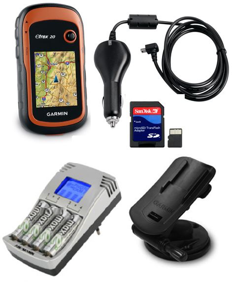
GPS DEVICE handheld (Garmin eTrex 30) + accessories

Valid Article
|
|
|
|
|
|
 OC validations: approved for procurement and use by an OC for international or local orders specifying context and activity in Medical Standard Lists (MSL)
|
|
GPS DEVICE handheld (Garmin eTrex 30X)
Definition
Location-finding system which works by means of a receiver that picks up signals transmitted by a network of satellites.
Specifications
Open article
- portable GPS receiver, with high sensitivity receiver
- altimeter (accuracy 1-3 m)
- compass (accuracy ± 5º)
- 240x320 pixels, transflective, 65-K color TFT
- meets IPX7 waterproofness standard and is strong enough for intensive use
- batteries: 2x AA/R6 1.5 V
- operating time: 25 hours minimum
- 3.7GB memory
Functions:
- number of waypoints savable: 2000
- number of routes savable: 200
- number of tracks savable: 200 (10,000 points)
- trip computer (odometer) showing:
- stopping times and total elapsed time
- speed (average, maximum and current)
- sunrise and sunset
- custom maps compatible
Accessories included:
- strap
- case
- PC interface cable
- cigar lighter adaptor
- quick reference guide and instruction manual
Optional accessories:
- external antenna
- car mounting kit
- battery charger with 4 AA/R6 batteries
Instructions for use
This GPS enables the geographical coordinates of locations related to MSF missions (villages, refugee camps, boreholes, health facilities, etc.) to be collected and transmitted to headquarters to be incorporated into maps.
The barometric altimeter determines the altitude by tracking changes in pressure. It can be used to plot barometric or ambient pressure over time in order to keep an eye on changing weather conditions.
The official software for the device, MapSource, is sold separately. Other software may also be used (OziExplorer, etc.). Ensure that you have a valid licence.
If this GPS is to be used in a vehicle, an external antenna should be ordered (see "Related Articles" below).
Warnings
- GPS equipment is prohibited in some countries and is often regarded as espionage equipment.
- A GPS does not take the place of a compass or a clinometer.
- The accuracy of the coordinates depends on the number of satellites the GPS can "see" (at least 3 for longitude/ latitude and at least 4 for longitude/latitude/altitude).
- The GPS satellites are operated by the US Department of Defense. Transmissions may be jammed or discontinued in some "contexts" (such as wartime).
- Mapmaking is a profession. The use of GPS by MSF missions should be limited to the recording of geographical coordinates as described above.
![[KPROKGIS001] KIT, GEOGRAPHIC INFORMATION SYSTEM](/web/image/product.template/562098/image_256/%5BKPROKGIS001%5D%20KIT%2C%20GEOGRAPHIC%20INFORMATION%20SYSTEM?unique=9cd83b0)
![[KWATMDEN01-] MODULE, ENTOMOLOGICAL ASSESSMENT](/web/image/product.template/552009/image_256/%5BKWATMDEN01-%5D%20MODULE%2C%20ENTOMOLOGICAL%20ASSESSMENT?unique=624bd97)
![[PCOMGPSTG3B] (Garmin eTrex 30X) CARRYING BAG](/web/image/product.template/565287/image_256/%5BPCOMGPSTG3B%5D%20%28Garmin%20eTrex%2030X%29%20CARRYING%20BAG?unique=e1ab316)
![[PCOMGPSTGEC] (GPS Garmin eTrex) CABLE transfer PC, USB + power cable](/web/image/product.template/564604/image_256/%5BPCOMGPSTGEC%5D%20%28GPS%20Garmin%20eTrex%29%20CABLE%20transfer%20PC%2C%20USB%20%2B%20power%20cable?unique=45a0c6d)