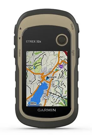
GPS DEVICE (Garmin eTrex 32) + accessories, set

Valid Article
|
|
|
|
|
|
 OC validations: approved for procurement and use by an OC for international or local orders specifying context and activity in Medical Standard Lists (MSL)
|
|
GPS DEVICE (Garmin eTrex 32) + accessories, set
Definition
GPS is Location-finding system which works by means of a receiver that picks up signals transmitted by a network of satellites.
This is a small and rugged handheld device used for personal naviagtion and basic mapping.
Specifications
General | |
Display size | 1.4" x 1.7" (3.5 x 4.4 cm); 2.2" diag (5.6 cm) |
Display resolution | 240 x 320 pixels |
Display type | 2.2" transflective, 65K color TFT |
Weight | 5 oz (141.7 g) with batteries |
Battery type | 2 AA batteries (not included); NiMH or Lithium recommended |
Battery life | 25 hours |
Water rating | IPX7 |
High-sensitivity receiver | yes |
Interface | mini USB |
Memory/History | 8 GB |
Maps & Memory | |
Preloaded maps | yes (TopoActive; routable) |
Ability to add maps | yes |
Basemap | yes |
Automatic routing (turn by turn routing on roads) for outdoor activities | yes |
Map segments | 3000 |
BirdsEye | 250 BirdsEye Imagery files |
Includes detailed hydrographic features (coastlines, lake/river shorelines, wetlands and perennial and seasonal streams) | yes |
Includes searchable points of interests (parks, campgrounds, scenic lookouts and picnic sites) | yes |
Displays national, state and local parks, forests, and wilderness areas | yes |
External memory storage | yes (32 GB max microSD™ card) |
Waypoints/favorites/locations | 2000 |
Tracks | 200 |
Track log | 10000 points, 200 saved tracks |
Routes | 200 routes, 250 points per route; 50 points auto routing |
Sensors | |
GPS | yes |
GLONASS | yes |
Barometric altimeter | yes |
Compass | Yes (tilt-compensated 3-axis) |
GPS compass (while moving) | yes |
Dimensions
Physical dimensions | 2.1" x 4.0" x 1.3" (5.4 x 10.3 x 3.3 cm) |
Instructions for use
This GPS enables the geographical coordinates of locations related to MSF missions (villages, refugee camps, boreholes, health facilities, etc.) to be collected and transmitted to headquarters to be incorporated into maps.
For personal navigation waypoints tracks can be uploaded to the device and advanced users can create and upload custom maps.
Warnings
- GPS equipment is prohibited in some countries and is often regarded as espionage equipment.
- A GPS does not take the place of a compass or a clinometer.
- The accuracy of the coordinates depends on the number of satellites the GPS can "see" (at least 3 for longitude/ latitude and at least 4 for longitude/latitude/altitude).
- The GPS satellites are operated by the US Department of Defense. Transmissions may be jammed or discontinued in some "contexts" (such as wartime).
- Mapmaking is a profession. The use of GPS by MSF missions should be limited to the recording of geographical coordinates as described above.