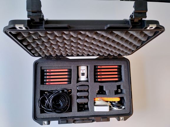
KIT, MOBILE DATA COLLECTION
Valid Article
KIT, MOBILE DATA COLLECTION
Definition
The MDC Kit integrates all specics tools necessary for data collection using smartphones via a georeferenced mobile survey application.
No specic Mobile data collection application is installed by default. The GIS Unit recommends the use of OsmAnd and ODK Collect.
Indications
The GIS kit for mobile data collection (MDC) contains everything needed for mobile data collection in projects. It allows you to collect data in the field using mobile devices such as mobile phones.
Mobile data collection is:
- faster: Data does not need to be transcribed from paper to computers before it can be analysed.
- more accurate:Enumeration errors are minimised because of the data validation that can occur in real time as the data is collected. Transcription errors are entirely eliminated.
- easy to use in field conditions: It works offline, is easy to use (requires no technical knowledge to manage and enumerators can be trained within minutes)
- flexible: survey forms can be adapted as needed
Functions:
- record GPS points
- collect non GDPR survey data with smartphones
- transfer mobile data to a computer
- stock and manage data (gpx, xls, etc.)
- record a GPS track
- draw georeferenced lines and polygones
Specifications
Size: 48.7 x 32.5 x 17.5 cm
Weight: 6.25 kg
Components
- rugged smartphones, 10 pcs
- Lacie rugged Secure 2 TB Hard drive, 1 pcs
- Skross-Pro World adapter USD Multiplug, 1 pcs
- Scandisc Ultra Dual Drive M3.m 32GB Flash disc, 1 pcs
- TP Link TL-MR3020 Wlan router 3G, 1 pcs
- Icy Box IB-AC6110 USB Hub 3.0, 1 pcs
- Peli 1485 Air Case, 1 pcs
Accessories included:
- 10x USB C cable to A male
- 10x plug for USB A charger
- 1x USB 3.0 cable A male to micro B (for hard drive)
- 1x power cable with switching adapter (for USB hub)
- 1x USB 3.0 cable A male to type B (for USB hub)
Instructions for use
Do follow instructions provided with kit.
Ask advice of your GIS specialist or GIS focal point before usage, when you have any doubt or if you require assistance in the planning and implementation mobile data collection in your project.
Please consult the map centres resource site for technical briefs and resources related to mobile data collection: https://mapcentre.msf.org/en/resource-centre.
The phones are equipped with an internal rechargeable battery: do not expose the product to excessive heat such as sunshine, fire or the like.
Before to deploy the MDC Kit, install OsmAnd and ODK Collect Apps on the smartphones.
The OSMand Apps enables the geographical coordinates of locations related to MSF missions (villages, refugee camps, boreholes, health facilities, roads, etc.) to be collected and transmitted to headquarters to be incorporated into maps.
The ODK Collect Apps enables to realize eld survey with a prior designed form. After the collect, data is transmited to the HQ for their management and their analyse.
Warning
- The number of smartphones is limited to 15 per capita in airplanes
- The accuracy of the coordinates depends on the number of satellites the GPS can "see" (at least 3 for longitude/ latitude and at least 4 for longitude/latitude/altitude)
- There are four different GPS satellites systems: Galileo (European), Beidou (Chinese), Glonass (Russian) and GPS (US)
- Mapmaking is a profession. The use of GPS by MSF missions should be limited to the recording of geographical coordinates as described above


![[ADAPPHON0G-] SMARTPHONE reinforced for GIS kit + acc.](/web/image/product.template/562754/image_256/%5BADAPPHON0G-%5D%20SMARTPHONE%20reinforced%20for%20GIS%20kit%20%2B%20acc.?unique=1ab3b78)
![[ADAPHDDE2UR] HARD DISK external (LaCie 9000298) mini 2TB, rugged](/web/image/product.template/562140/image_256/%5BADAPHDDE2UR%5D%20HARD%20DISK%20external%20%28LaCie%209000298%29%20mini%202TB%2C%20rugged?unique=277d91d)
![[PELEPLUGAWAS5] ADAPTER multinational (SKROSS PRO 5775720) 100-250V](/web/image/product.template/562141/image_256/%5BPELEPLUGAWAS5%5D%20ADAPTER%20multinational%20%28SKROSS%20PRO%205775720%29%20100-250V?unique=bcc79bb)
![[ADAPMEMOKG32S] MEMORY KEY (SanDisk) 32Gb, USB 3.0](/web/image/product.template/562142/image_256/%5BADAPMEMOKG32S%5D%20MEMORY%20KEY%20%28SanDisk%29%2032Gb%2C%20USB%203.0?unique=1cce93f)
![[ADAPNETWRT3] ROUTER WLAN (TL-MR3020) 150Mbps](/web/image/product.template/562091/image_256/%5BADAPNETWRT3%5D%20ROUTER%20WLAN%20%28TL-MR3020%29%20150Mbps?unique=212ae93)
![[ADAPLAPAIA6H] HUB USB 10 ports (ICY BOX IB-AC6110)](/web/image/product.template/562093/image_256/%5BADAPLAPAIA6H%5D%20HUB%20USB%2010%20ports%20%28ICY%20BOX%20IB-AC6110%29?unique=212ae93)
![[PPACBOXPA43P] AIR CASE (PELI 1485)](/web/image/product.template/562137/image_256/%5BPPACBOXPA43P%5D%20AIR%20CASE%20%28PELI%201485%29?unique=f8ad5ea)