KIT, GEOGRAPHIC INFORMATION SYSTEM

Valid Article
|
|
|
|
|
|
 OC validations: approved for procurement and use by an OC for international or local orders specifying context and activity in Medical Standard Lists (MSL)
|
|
KIT, GEOGRAPHIC INFORMATION SYSTEM
Definition
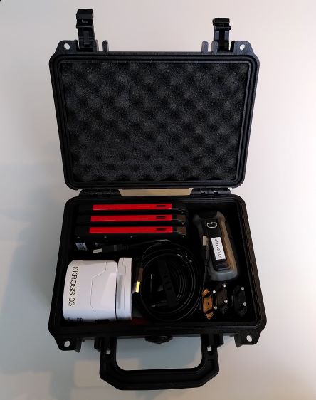
The GIS kit integrates all specifics tools necessary for georeferenced data collection, management and analysis.
No specific Mobile data collection application is installed by default. The GIS Unit recommends the use of OsmAnd and ODK Collect.
Indications
Functions:
- record GPS points
- draw georeferenced lines and polygones
- record a track by GPS
- transfer mobile data and GPS to a computer
- stock and manage data (gpx, xls, etc.)
Specifications
Dimensions : 24 x 19.8 x 10.9 cm
Weight: 2.35 kg
Components
| Qty | Article | Type | Accessories |
| 1x | reinforced suitcase | PELI 1150 protector case | |
| 2x | GPS device | Garmin eTrex 30x | - USB 3.0 cable A male to mini B |
| 3x | smartphone | - Crosscall Core X3 - Samsung Xcover 4S - or equivalent smartphone | - USB C or micro B to A male - plug for USB A charger |
| 1x | reinforced hard drive | Drive LaCie rugged secure 2TB | - USB 3.0 cable A male to micro B |
| 1x | USB memory key | USB Scandisk - ultra dual drive M3.0 (32GB) | |
| 1x | international adapter | Multiplug SKROSS-PRO World Adapter USB | |

Instructions for use
Before the deployment of the GIS kit, install the last version of OsmAnd and ODK Collect apps on the smartphones.
The OsmAnd app together with the GPS device, enables collection of the geographical coordinates of locations related to MSF missions (villages, refugee camps, boreholes, health facilities, roads, etc.) and allows these to be transmitted to HQ to be incorporated into maps.
The ODK Collect app enables to realise a field survey with a prior design form. After the collection, the data is transmitted to the HQ for their management and their analyse.
The phones are equipped with an internal rechargeable battery: do not expose the product to excessive heat such as sunshine, fire or the like.
Warning
- The number of smartphones is limited to 15 per capita by airplanes
- The accuracy of the coordinates depends on the number of satellites the GPS can "see" (at least 3 for longitude/lattidude/altitude
- There are four different GPS satellites systems: Galileo (European), Beidou (Chinese), Glonass (Russian) and GPS (US)
- Mapmaking is a profession. The use of GPS by MSF missions should be limited to the recording of geographical coordinates as described above

![[ADAPPHON0G-] SMARTPHONE reinforced for GIS kit + acc.](/web/image/product.template/562754/image_256/%5BADAPPHON0G-%5D%20SMARTPHONE%20reinforced%20for%20GIS%20kit%20%2B%20acc.?unique=b482f0a)
![[PCOMGPSTG3-] GPS DEVICE handheld (Garmin eTrex 30) + accessories](/web/image/product.template/557409/image_256/%5BPCOMGPSTG3-%5D%20GPS%20DEVICE%20handheld%20%28Garmin%20eTrex%2030%29%20%2B%20accessories?unique=b3eb249)
![[ADAPHDDE2UR] HARD DISK external (LaCie 9000298) mini 2TB, rugged](/web/image/product.template/562140/image_256/%5BADAPHDDE2UR%5D%20HARD%20DISK%20external%20%28LaCie%209000298%29%20mini%202TB%2C%20rugged?unique=e465754)
![[PELEPLUGAWAS5] ADAPTER multinational (SKROSS PRO 5775720) 100-250V](/web/image/product.template/562141/image_256/%5BPELEPLUGAWAS5%5D%20ADAPTER%20multinational%20%28SKROSS%20PRO%205775720%29%20100-250V?unique=6ec8e1e)
![[ADAPMEMOKG32S] MEMORY KEY (SanDisk) 32Gb, USB 3.0](/web/image/product.template/562142/image_256/%5BADAPMEMOKG32S%5D%20MEMORY%20KEY%20%28SanDisk%29%2032Gb%2C%20USB%203.0?unique=af8640f)
![[PPACBOXPR29P] PROTECTOR CASE (PELI 1150)](/web/image/product.template/562133/image_256/%5BPPACBOXPR29P%5D%20PROTECTOR%20CASE%20%28PELI%201150%29?unique=671a2f4)